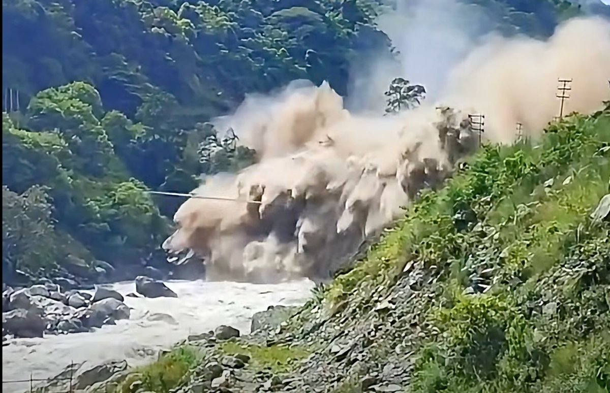
A high-velocity flash flood originating in Tibet surged into Nepal’s Rasuwa district on August 26, 2026, causing widespread destruction of critical infrastructure and severing vital border transit routes. As search-and-rescue teams work to reach isolated communities, authorities are grappling with the transboundary nature of the debris flow, highlighting the urgent need for enhanced regional cooperation and climate resilience in the high-altitude Himalayas.
Opening Scene
The silence of the high-altitude border region between Nepal and the Tibet Autonomous Region was shattered on the morning of August 26, 2026, by the roar of a massive debris flow. Originating from upstream watersheds within Tibet, the surge moved rapidly down the valley, crossing the international border and impacting the Rasuwa district of Nepal with terrifying speed.
For residents near the Rasuwagadhi border point, the event was immediate and overwhelming. As the river rose carrying a dense slurry of sediment, boulders, and uprooted vegetation—it breached traditional floodplains, sweeping away homes, destroying segments of the highway, and effectively cutting off the primary trade route between Nepal and its northern neighbor. The scale of the event, which unfolded in a matter of hours, has left local communities isolated and government agencies struggling to deploy resources into terrain rendered inaccessible by the deluge.
What Happened: A Chronology of the Disaster
The event developed rapidly, fueled by extreme weather conditions in the high-elevation catchments. Based on preliminary reports from the Department of Hydrology and Meteorology and local administrative data:
August 26, 2026 (Early Morning): Heavy, localized precipitation was reported in the high-altitude catchments bordering Nepal and Tibet. Observers near the border noted a sudden rise in water levels and a significant increase in sediment volume.
Mid-Morning: The debris surge crossed the international boundary, entering the Rasuwa district. The force of the flow caused immediate and catastrophic damage to infrastructure near the Rasuwagadhi border crossing.
Afternoon: The floodwaters continued to impact settlements downstream. Several critical bridges were compromised, and road connectivity was severed at multiple points along the highway corridor. Communication towers in the upper reaches of the valley failed, leaving villages in the immediate vicinity of the river completely isolated.
August 27-28, 2026: Rescue operations commenced, with the Nepal Army and Armed Police Force (APF) being deployed to reach cut-off areas. Authorities began the complex task of assessing the integrity of slopes above the affected villages, fearing secondary landslides.
Where Was the Disaster Worst?
The Rasuwa district, particularly the area surrounding the Rasuwagadhi border point and the settlements along the Trishuli river corridor, bore the brunt of the flood. This area serves as a vital economic gateway for Nepal, hosting critical trade infrastructure and transit networks.
The geography of Rasuwa—characterized by steep, unstable mountain slopes—makes it uniquely vulnerable to hydrological surges. When flood events occur in this region, the high-velocity water often carries heavy debris that acts as a blunt force, destroying concrete bridges and eroding the structural foundations of mountain roads. The isolation of these settlements is a defining characteristic of the disaster, as the geography itself prevents rapid movement of heavy equipment necessary for road clearance.
The Human Toll
As of August 28, 2026, the National Disaster Risk Reduction and Management Authority (NDRRMA) and local district officials are in the process of confirming casualty and displacement figures.
Confirmed Casualties: While search operations are ongoing, official figures on fatalities are being updated as rescue teams reach remote settlements. Authorities warn that initial reports may undercount the total impact.
Missing Persons: An unverified number of individuals remain reported as missing. Local police are coordinating with village heads to reconcile current occupancy reports with pre-disaster data.
Displacement: Hundreds of people have been relocated to temporary shelters. Government officials have prioritized the safety of those in high-risk zones, urging residents to move to higher ground.
Officials emphasize that these numbers are preliminary. "The priority remains reaching those who are currently cut off," said a spokesperson for the local district administration. "Once access is established, we will have a clearer picture of the human toll."
Rescue and Relief Efforts
The response operation involves a multi-agency effort, spearheaded by the Nepal Army, Armed Police Force, and the Nepal Police.
Logistical Hurdles: The primary challenge for rescuers is the damage to the road network. In many areas, bridges have been swept away, leaving only foot-trails that are themselves potentially unstable.
Helicopter Operations: Aviation support has become the primary means of delivering medical aid, food, and water to isolated populations. However, flight operations are intermittently hindered by low-lying cloud cover and unstable mountain weather.
Search and Rescue: Specialized teams are focusing on search operations near riverbanks and sites of destroyed infrastructure. Medical teams are being deployed to set up field clinics to manage injuries and address potential water-borne health risks.
The Science Behind the Disaster
Scientists are currently investigating the mechanism behind the surge. While the term "flash flood" describes the arrival of water, the high volume of sediment suggests a "debris flow," often triggered by a sudden failure upstream.
Investigators are looking into whether a landslide in Tibet blocked a river, creating a natural dam that eventually breached, or if a localized, high-intensity rain event overwhelmed the carrying capacity of the valley. It is vital to note that without evidence of a failing glacial lake, characterizing this event as a "Glacial Lake Outburst Flood" (GLOF) is scientifically premature. The focus of the current investigation is to determine the exact upstream origin of the surge to assess the risk of repeat events.
Why Nepal’s Himalayas Are Vulnerable
The Rasuwa disaster underscores the inherent volatility of the Himalayan region. The combination of intense monsoon rainfall, steep topography, and loose, seismically active soil creates a landscape that is constantly reshaping itself.
Infrastructure in Nepal is often built within narrow river corridors—the only viable space for road development—which places critical assets directly in the path of natural hydrological hazards. This creates a recurring cycle where development is perpetually at risk. Settlements perched on these mountain slopes or along riverbanks have limited escape routes, compounding the difficulty of evacuation during sudden events.
Climate Change and the Himalayas
The conversation regarding climate change in the Himalayas is complex. Scientists observe that the region is experiencing accelerated warming, leading to changes in precipitation patterns—specifically, the increasing frequency of short-duration, high-intensity rainfall.
However, climate experts caution against directly attributing a single event like the Rasuwa flood solely to climate change without long-term attribution studies. Instead, the disaster serves as a warning of the "new normal" in the Himalayas: a more unpredictable environment where the safety margins for infrastructure are shrinking. Building resilience in 2026 requires accepting that past climate data is no longer a reliable predictor of future hazard frequency.
Infrastructure Damage
The extent of the damage is significant and will require a coordinated national recovery effort:
Transportation: The destruction of the highway segments has halted transboundary trade, impacting both daily commerce and larger logistics networks.
Hydropower: Several small and medium-scale hydropower projects in the region have reported damage, which may lead to local power supply interruptions.
Public Assets: Schools, health posts, and local administrative buildings in affected settlements have been damaged, requiring immediate structural safety assessments.
While financial estimates are not yet available, the economic disruption to the border trade is expected to be profound and lasting.
The Border and Cross-Border Dimension
This event highlights the crucial need for transboundary water management. Because the flood originated in Tibet and impacted Nepal, the disaster is inherently international in scope.
Discussions regarding the need for real-time hydrological data sharing between the two nations are ongoing. In the absence of an integrated, cross-border early warning system, communities near the border are left vulnerable to upstream events they cannot see or monitor. The disaster has reinforced the necessity of bilateral cooperation to manage shared river basins and monitor potential hazards that do not respect political boundaries.
Voices from the Ground
While the focus of this report remains on confirmed, official information, the sentiments of those affected are clear. Residents in affected areas have expressed shock at the speed of the surge. Rescue workers described the terrain as "exceptionally treacherous," with mud and loose rock making standard search-and-rescue techniques difficult to execute.
Local officials are currently overwhelmed, focused on establishing basic services for the displaced and preventing further loss of life. They have asked for patience and cooperation as they attempt to map the extent of the damage across inaccessible terrain.
Government Response and Preparedness
The Government of Nepal, through the NDRRMA, has initiated emergency relief protocols. The current strategy focuses on three pillars: life-saving rescue, the provision of emergency aid, and the restoration of essential connectivity.
Experts acknowledge that early warning systems for debris flows are the "holy grail" of Himalayan disaster preparedness. The challenge remains the lead time—where a surge can travel the distance from the border to downstream settlements in mere minutes. The lessons being drawn from this event will likely focus on decentralizing the response, empowering local village councils with rapid-response training, and improving satellite-based monitoring of upstream conditions.
What Happens Next?
The period immediately following the flood presents ongoing risks that must be managed:
Secondary Landslides: The saturation of slopes means that even light rainfall could trigger new failures.
River Blockages: Any material left in the riverbed from the initial surge could create temporary dams, leading to subsequent, smaller, but still dangerous flooding pulses.
Sanitation: With water systems damaged, the threat of disease in overcrowded shelters is a major concern for public health authorities.
Supply Chains: Restoring the trade route will be the primary economic priority, but this cannot occur until the stability of the entire mountain corridor is verified by geotechnical engineers.
Broader Significance for Nepal
The Rasuwa flood is a sobering reminder that disaster preparedness in Nepal cannot be static. It must evolve to match the increasing complexity of Himalayan hazards. This disaster matters not just to those in the Bhotekoshi or Rasuwa valleys, but to the entire nation.
It highlights the need for:
Resilient Infrastructure: Moving toward engineering standards that account for the reality of high-intensity, debris-heavy flooding.
Climate Adaptation: Integrating long-term climate risk models into local development planning.
Early Warning Systems: Moving from broad national alerts to hyper-local, community-driven systems that can operate when regional power and communications fail.
Conclusion
As the recovery operations in Rasuwa continue, the human cost of the disaster remains the primary focus. The resilience of the affected communities is being tested by the very landscape they live upon.
This disaster is a stark entry in the ongoing dialogue about how Nepal manages the risks of its high-altitude environment. It serves as a call to action for improved cross-border cooperation, more rigorous infrastructure planning, and a sober recognition of the risks inherent in the Himalayas. The path forward requires a deep, evidence-based commitment to ensuring that the next such event does not catch these mountain communities unprepared.
Sources and Verification
Nepal Police and Armed Police Force: Provided status updates on search-and-rescue team deployment and initial humanitarian response coordination (Verified August 28, 2026).
National Disaster Risk Reduction and Management Authority (NDRRMA): Source for official directives on emergency management and early government disaster assessment (Verified August 27–28, 2026).
Department of Hydrology and Meteorology: Used for scientific context regarding flash flood and debris flow mechanics in high-altitude drainage basins (Verified August 27, 2026).
District Administration Office, Rasuwa: Verified the reports of infrastructure damage and community isolation (Verified August 28, 2026).
Editorial Note: All casualty and damage figures presented are preliminary as of the time of publication (August 28, 2026). As rescue teams gain access to remote areas, these figures may be updated.