Langtang Region Guide 2026/27: Valley of Glaciers, Tamang Culture & Gosaikunda
The Langtang region sits just 80 kilometres north of Kathmandu, yet it feels like a different world. Known as the "Valley of Glaciers," Langtang packs extraordinary Himalayan scenery, rich Tamang culture, and one of Nepal's most sacred alpine lakes into a compact area that you can reach by road in a single day from the capital. For trekkers who want high mountain views without the flight to Lukla or the crowds of Annapurna, Langtang is the sweet spot.
This guide covers every major trekking route in the Langtang region for the 2026/27 season: the classic Langtang Valley trek, the sacred Gosaikunda Lake pilgrimage, the cultural Tamang Heritage Trail, and the high-altitude challenge of Tserko Ri. You will find honest difficulty ratings, permit requirements, day-by-day itinerary outlines, and practical advice on when to go and what to expect. If you are planning your first Himalayan trek or adding a new region to your list, start here.
For a broader perspective on Nepal's trekking landscape, see our guide to choosing a trek in Nepal. And if you are still deciding which trekking agency to trust with your Langtang adventure, our guide to the best trekking agency in Nepal walks you through what to look for.
Why the Langtang Region?
Langtang National Park, established in 1976 as Nepal's first Himalayan national park, protects 1,710 square kilometres of diverse ecosystems ranging from subtropical forests at 1,000 metres to the summit of Langtang Lirung at 7,227 metres. The park is home to red pandas, Himalayan black bears, snow leopards, musk deer, and over 250 bird species. But what makes Langtang special is not just its biodiversity - it is the human landscape.
The region is predominantly inhabited by the Tamang people, an ethnic group with deep Tibetan roots. Their language, dress, architecture, and Buddhist practices create a living cultural tapestry that you experience in every village along the trail. Stone houses with carved wooden windows, colourful prayer flags fluttering above mani walls, ancient monasteries where butter lamps burn continuously - these are not museum pieces; they are daily life.
Access is another advantage. The trailhead at Syabrubesi is a 7-8 hour drive from Kathmandu on a paved road (with the final section gravel), meaning you can be on the trail the same day you leave the city. No domestic flights, no weather delays, no Lukla anxiety. For trekkers with limited time or a tight budget, Langtang delivers maximum Himalayan immersion for minimum logistical friction.
Langtang Region Trekking Routes at a Glance
| Route | Days | Max Altitude | Difficulty | Best Season |
|---|---|---|---|---|
| Langtang Valley Trek | 7-10 | 4,984 m (Tserko Ri) | Moderate | Mar-May, Oct-Nov |
| Gosaikunda Lake Trek | 5-7 | 4,380 m (Gosaikunda) | Moderate-Challenging | Mar-May, Oct-Nov |
| Tamang Heritage Trail | 7-8 | 3,165 m (Nagthali) | Easy-Moderate | Year-round |
| Langtang Valley + Gosaikunda Combined | 10-12 | 4,984 m (Tserko Ri) | Challenging | Mar-May, Oct-Nov |
| Helambu Trek (via Lauribina Pass) | 6-8 | 4,610 m (Lauribina Pass) | Moderate-Challenging | Mar-May, Oct-Nov |
Langtang Valley Trek (7-10 Days)
The Langtang Valley trek is the region's flagship route. It follows the Langtang River upstream through forests of rhododendron, oak, and bamboo, past waterfalls and landslide scars that tell the story of the 2015 earthquake, to the alpine meadows of Kyanjin Gompa. From there, a day hike to Tserko Ri (4,984 m) delivers one of the most concentrated mountain panoramas in Nepal - Langtang Lirung, Gangchempo, Dorje Lakpa, Yala Peak, Naya Kanga, and the Shishapangma massif in Tibet all visible in a single 360-degree sweep.
Standard 8-Day Itinerary
Day 1: Drive Kathmandu to Syabrubesi (1,550 m) - 7-8 hours. Overnight in Syabrubesi.
Day 2: Trek Syabrubesi to Lama Hotel (2,380 m) - 6 hours. Through forest along the Bhote Koshi and Langtang rivers.
Day 3: Trek Lama Hotel to Langtang Village (3,430 m) - 6-7 hours. The valley opens up; first views of Langtang Lirung.
Day 4: Trek Langtang Village to Kyanjin Gompa (3,870 m) - 3-4 hours. Short day for acclimatisation. Visit the monastery and cheese factory.
Day 5: Acclimatisation day at Kyanjin Gompa. Hike to Tserko Ri (4,984 m) for sunrise - 6-7 hours round trip. Or hike to Langshisa Kharka / Yala Peak base camp.
Day 6: Trek Kyanjin Gompa to Lama Hotel - 5-6 hours.
Day 7: Trek Lama Hotel to Syabrubesi - 5 hours.
Day 8: Drive Syabrubesi to Kathmandu.
A 7-day version combines Days 6 and 7 into a long descent to Syabrubesi. A 10-day version adds a rest day at Kyanjin and a side trip to the Langtang Glacier or Yala Peak base camp.
Difficulty and Fitness
Rated moderate. The trail is well-established with teahouses at regular intervals. Daily walking times range from 3 to 7 hours. The main challenge is altitude - you gain over 2,300 metres from Syabrubesi to Kyanjin Gompa in three days. The Tserko Ri day hike adds another 1,100 metres of ascent. Trekkers with no prior altitude experience should take the 8-day itinerary seriously and consider diamox prophylaxis. For a detailed altitude safety guide, see our altitude sickness prevention guide for Everest and Annapurna treks (the principles apply equally to Langtang).
Gosaikunda Lake Trek (5-7 Days)
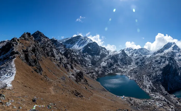
Gosaikunda is one of Nepal's most sacred alpine lakes, sitting at 4,380 metres in a rocky amphitheatre surrounded by peaks. Hindu mythology holds that Lord Shiva created the lake by striking the mountain with his trident to quench his thirst after swallowing poison during the churning of the ocean. Every August, during the Janai Purnima festival, thousands of pilgrims trek here to bathe in the icy waters. For trekkers, Gosaikunda offers a shorter, steeper route to high-altitude scenery with profound spiritual atmosphere.
Standard 6-Day Itinerary (from Dhunche)
Day 1: Drive Kathmandu to Dhunche (1,960 m) - 6-7 hours.
Day 2: Trek Dhunche to Sing Gompa / Chandanbari (3,250 m) - 5-6 hours. Steep climb through forest.
Day 3: Trek Sing Gompa to Gosaikunda (4,380 m) - 4-5 hours. Cross Lauribina Pass (3,920 m). First views of the lake.
Day 4: Explore Gosaikunda area. Optional hike to Surya Kunda, Bhairav Kunda, or Saraswati Kunda. Acclimatisation day.
Day 5: Trek Gosaikunda to Dhunche via Lauribina Pass - 7-8 hours. Long descent.
Day 6: Drive Dhunche to Kathmandu.
This route can be combined with the Langtang Valley trek for a 10-12 day circuit: ascend Langtang Valley to Kyanjin, cross the high pasture to Gosaikunda, then descend via Lauribina Pass to Dhunche. This combination is one of Nepal's most rewarding two-week treks, linking glacial valleys, sacred lakes, and Tamang culture in a single continuous walk.
Difficulty and Fitness
Rated moderate to challenging. The ascent from Dhunche to Gosaikunda gains nearly 2,500 metres in two days - faster than the Langtang Valley approach. Altitude sickness risk is higher. The Lauribina Pass crossing (3,920 m) can be snow-covered into May and from November. Trekkers should be comfortable with 6-8 hour days at altitude and carry warm layers even in spring.
Tamang Heritage Trail (7-8 Days)
If your priority is cultural immersion over high-altitude drama, the Tamang Heritage Trail delivers. This community-based tourism route winds through traditional Tamang villages in the lower Langtang region, staying in homestays and locally-run lodges where your fees directly support village development funds. The maximum altitude is Nagthali (3,165 m), making it accessible year-round and suitable for trekkers who want to avoid serious altitude.
Standard 7-Day Itinerary
Day 1: Drive Kathmandu to Syabrubesi (1,550 m).
Day 2: Trek Syabrubesi to Gatlang (2,238 m) - 5-6 hours. Traditional Tamang village with stone houses and a monastery.
Day 3: Trek Gatlang to Tatopani (2,607 m) - 6-7 hours. Natural hot springs at Tatopani.
Day 4: Trek Tatopani to Thuman (2,338 m) via Nagthali (3,165 m) - 6 hours. Nagthali offers panoramic views of Langtang Lirung and the Ganesh Himal.
Day 5: Trek Thuman to Briddim (2,229 m) - 5-6 hours. Homestay in a traditional Tamang house.
Day 6: Trek Briddim to Syabrubesi - 3-4 hours.
Day 7: Drive Syabrubesi to Kathmandu.
Why Choose the Heritage Trail?
You will share meals with Tamang families, learn to make momos, participate in a Buddhist puja ceremony, and hear oral histories of the 2015 earthquake from survivors. The trail was developed with support from the Tourism for Rural Poverty Alleviation Programme and is a model for community-based tourism in Nepal. For more on responsible travel in Nepal, see our guide to responsible and community tourism in Nepal (coming soon).
Permits for the Langtang Region
Every trek in Langtang requires two permits:
Langtang National Park Entry Permit: NPR 3,000 for foreign nationals, NPR 1,500 for SAARC nationals. Available at the Nepal Tourism Board office in Kathmandu or at the park entry checkpoint in Dhunche. Carry your passport and two passport photos.
TIMS (Trekkers' Information Management System) Card: NPR 2,000 for individual trekkers, NPR 1,000 for group trekkers (through a registered agency). If you book through a registered trekking agency in Nepal, your TIMS card is included in the package and handled for you.
Both permits are checked at multiple checkpoints. Keep them in a waterproof pouch. For a complete breakdown of all Nepal trekking permits including restricted area fees, read our Nepal trekking permits and TIMS guide.
Best Time to Trek Langtang
October-November (autumn): Peak season. Stable weather, clear skies, comfortable daytime temperatures (10-20°C at 3,000 m). Trails and teahouses are busiest. Book accommodation early.
March-May (spring): Second peak season. Warmer temperatures, rhododendron forests in full bloom (spectacular in April), longer daylight hours. Afternoon clouds more common than in autumn. Excellent for photography.
December-February (winter): Cold but viable on lower routes. The Tamang Heritage Trail and lower Langtang Valley (up to Kyanjin) remain accessible. Tserko Ri and Gosaikunda may have heavy snow; Lauribina Pass often closes. Teahouses at higher elevations may shut for the season - check ahead. Crystal-clear mountain views and very few trekkers.
June-September (monsoon): Not recommended for Langtang Valley or Gosaikunda. Heavy rain, leeches, landslide risk on the road to Syabrubesi, and obscured mountain views. The region does not lie in a strong rain shadow like Upper Mustang or Dolpo.
For a detailed month-by-month breakdown across all of Nepal, see our best time to visit Nepal guide.
Teahouses and Accommodation
Langtang Valley and Gosaikunda routes have a well-established teahouse network. Rooms are typically twin-share with foam mattresses, blankets, and pillows. Bring a sleeping bag rated to -10°C for treks above 3,500 m - teahouse blankets are often insufficient at altitude. Hot showers cost NPR 200-500 extra. Wi-Fi is available at most lodges up to Kyanjin Gompa for a small fee (NPR 100-300/hour), but becomes unreliable above 3,500 m.
The Tamang Heritage Trail uses a mix of teahouses and homestays. Homestays offer a more authentic experience but simpler facilities - often shared bathrooms and no hot shower. The cultural exchange more than compensates.
On busy routes (Langtang Valley in October, Gosaikunda during Janai Purnima), teahouses fill up. Your guide will call ahead to reserve rooms. For a comparison of teahouse vs camping trekking across Nepal, see our teahouse vs camping trekking guide.
Food and Water
Teahouse menus are standardised across the region: dal bhat (rice, lentils, vegetables, pickle), noodles, soups, fried rice, pancakes, porridge, eggs, and Tibetan bread. Dal bhat is the trekking staple - unlimited refills on rice and lentils in most places. Vegetarian options are plentiful; meat is available but not recommended above 3,000 m due to storage concerns.
Drink boiled or filtered water. Carry a water bottle or hydration bladder and refill with boiled water at teahouses (usually NPR 100-200 per litre). Water purification tablets or a UV steriliser (SteriPEN) are good backups. Avoid single-use plastic bottles - there is no recycling infrastructure on the trail.
Getting There: Road Access to Syabrubesi and Dhunche
Both main trailheads are reached by road from Kathmandu:
- Kathmandu to Syabrubesi (Langtang Valley / Tamang Heritage): 7-8 hours, ~120 km. The road is paved to Trisuli Bazaar, then gravel with ongoing upgrades. Local buses leave from Machhapokhari (Kathmandu) at 6-7 AM. Private jeep (recommended for comfort and timing) costs USD 150-200 one way for 4-6 people.
- Kathmandu to Dhunche (Gosaikunda): 6-7 hours, ~110 km. Same road to Trisuli, then branch north. Local buses from Machhapokhari. Private jeep USD 140-180.
Landslides can block the road during monsoon and after heavy rain. Always build a buffer day into your itinerary for the return drive.
Plan Your Langtang Trek
The Langtang region rewards every kind of trekker. If you have a week, the classic Langtang Valley to Kyanjin Gompa with a Tserko Ri summit gives you glaciers, high peaks, and Tibetan culture in a compact loop. If you want spiritual depth, add Gosaikunda Lake. If you prefer people over peaks, the Tamang Heritage Trail delivers authentic village life without serious altitude. And if you have two weeks, the Langtang-Gosaikunda circuit links them all into one of Nepal's most diverse trekking experiences.
Geology and Glacial Landscapes
The dramatic scenery of the Langtang region is the product of millions of years of tectonic collision and glacial sculpting. The Langtang Himal range marks the southern edge of the Tibetan Plateau, where the Indian plate continues to push northward beneath Eurasia at roughly five centimetres per year. This ongoing collision has thrust up the high peaks - Langtang Lirung (7,227 m), Gangchempo (6,388 m), Dorje Lakpa (6,966 m), and Yala Peak (5,520 m) - while carving deep U-shaped valleys and hanging valleys through successive glacial advances and retreats.
The Langtang Glacier, the longest in the region at over 20 kilometres, flows from the north face of Langtang Lirung down to the valley floor near Kyanjin Gompa. Its terminal moraine and outwash plain are visible from the trail, and the glacier itself can be reached on a half-day hike from Kyanjin. The Lirung Glacier, Kimshung Glacier, and Shalbachum Glacier feed the Langtang River, which becomes the Trisuli River downstream - a major tributary of the Narayani and eventually the Ganges system. For trekkers, this means the river you follow upstream from Syabrubesi is literally carrying meltwater from 7,000-metre peaks to the plains of India.
Evidence of the 2015 Gorkha earthquake is still visible along the Langtang Valley trail. The village of Langtang was almost entirely destroyed by a massive ice-and-rock avalanche triggered by the quake, which swept down from the north face of Langtang Lirung. Over 300 people perished, including locals, trekkers, and guides. The new Langtang Village sits slightly higher on the valley wall, rebuilt with international support. Memorial chortens and prayer flags mark the old village site - a sobering reminder of the mountains' power and the resilience of the Tamang people.
Wildlife and Biodiversity Highlights
Langtang National Park's elevation range - from roughly 1,000 metres at the Bhote Koshi gorge to 7,227 metres at Langtang Lirung - creates distinct ecological zones. In the lower temperate forests (1,500-2,500 m), you will walk through stands of oak, maple, alder, and blue pine, with a dense understory of bamboo and rhododendron. Spring brings the famous rhododendron bloom: entire hillsides turn crimson, pink, and white with Rhododendron arboreum, R. campanulatum, and R. lepidotum.
Above the tree line (around 3,200 m), the landscape opens into alpine meadows dotted with dwarf juniper, cotoneaster, and a spectacular array of wildflowers in summer: primulas, gentians, edelweiss, blue poppies (Meconopsis), and saxifrages. The park's 250+ bird species include the Himalayan monal (Nepal's national bird), blood pheasant, satyr tragopan, snow partridge, and the lammergeier (bearded vulture) soaring above the ridges.
Mammal sightings require luck and quiet early-morning walks. The red panda (Ailurus fulgens) inhabits the bamboo-thick forests between 2,200 and 4,000 m - Langtang is one of its strongholds in Nepal. Himalayan black bear, Himalayan tahr, goral, serow, and musk deer are present but elusive. Snow leopards range the high valleys above 4,000 m; their scrapes and pugmarks are occasionally found on the Tserko Ri trail. Langur monkeys are common around Kyanjin Gompa and the lower forests.
For a deeper dive into the Annapurna region's flora and fauna (many species overlap), see our flora, fauna and wildlife of Annapurna guide.
Side Trips and Extensions from Kyanjin Gompa
If you have an extra day or two at Kyanjin Gompa, these side trips add depth to your Langtang experience:
- Langtang Glacier (half day): Follow the moraine northeast from Kyanjin for 2-3 hours to the glacier snout. The trail crosses glacial streams and offers close views of the icefall cascading off Langtang Lirung. No technical gear needed, but wear sturdy boots for the moraine rubble.
- Yala Peak Base Camp (full day): Yala Peak (5,520 m) is a popular trekking peak. The base camp at ~4,800 m sits in a broad alpine basin with views of Shishapangma (8,027 m) across the border in Tibet. A 6-7 hour round trip from Kyanjin with moderate scrambling near the end.
- Kyanjin Ri (4,773 m, 3-4 hours round trip): The lower alternative to Tserko Ri. Steep but shorter, with excellent views of the Langtang Glacier and Langtang Lirung's north face. Good acclimatisation hike if Tserko Ri feels too ambitious.
- Langshisa Kharka (full day): A high pasture at ~4,300 m reached by continuing past Kyanjin up the Langtang Valley. Wild, open, and rarely visited. Yaks graze here in summer; you may see Himalayan tahr on the cliffs above.
Packing List Essentials for Langtang
Packing light is key - porters carry up to 20-25 kg, but you should aim for a 10-12 kg duffel. Essentials include:
- Base layers: Merino wool or synthetic top and bottom (2 sets)
- Mid layer: Fleece jacket or lightweight down vest
- Outer shell: Waterproof breathable jacket and pants (Gore-Tex or equivalent)
- Insulation: Down jacket rated to -10°C (essential for Tserko Ri and Gosaikunda)
- Trekking trousers: 2 pairs quick-dry, 1 pair warm fleece-lined
- Footwear: Broken-in trekking boots (mid-height, waterproof), camp shoes/sandals, 4-5 pairs merino socks, 2 liner socks
- Accessories: Warm beanie, sun hat, light gloves, heavy gloves/mittens, neck gaiter/buff, sunglasses (UV400), headlamp + spare batteries
- Sleep: Sleeping bag rated to -10°C (teahouse blankets are thin), sleeping bag liner
- Hydration: 2 L capacity (bottles or bladder), water purification tablets or SteriPEN
- Health: Personal meds, diamox (consult doctor), blister kit, electrolytes, sunscreen SPF50+, lip balm SPF30+
- Tech: Power bank (10,000+ mAh), camera, spare SD cards, universal travel adapter
- Documents: Passport, permits (park + TIMS), travel insurance (must cover trekking to 5,000 m), emergency contacts
For a comprehensive packing guide tailored to Annapurna (similar altitude profile), see our Annapurna trek packing list.
Helicopter Evacuation and Emergency Planning
Helicopter rescue is available from Kyanjin Gompa (helipad at ~3,850 m) and Gosaikunda (helipad near the lake at ~4,350 m). Evacuation to Kathmandu costs USD 3,000-5,000 depending on weather and helicopter type. Your travel insurance MUST cover high-altitude helicopter evacuation - many standard policies exclude trekking above 4,000 m or require a specific adventure sports rider. Carry your insurance policy number and emergency contact card at all times. Your guide will carry a satellite phone or radio for emergency communication.
Altitude sickness is the most common medical issue. Know the symptoms of AMS (headache, nausea, dizziness, fatigue), HAPE (breathlessness at rest, cough, frothy sputum), and HACE (confusion, ataxia, altered consciousness). The only cure is descent. Do not ascend with symptoms. For a full medical guide, revisit our altitude sickness prevention guide.
Browse our full range of Nepal trekking and tour packages to find your Langtang adventure, or explore our cultural and spiritual tours guide to combine your trek with Nepal's rich heritage.



Trekking & Expeditions
Cultural & Heritage Tours
Helicopter Tours
Wellness & Yoga Retreats
Tailor-Made Journeys
Licensed by Nepal Tourism Board
Local expert guides & Sherpas
Safety-first protocols
Transparent pricing, no hidden fees
24/7 support on the ground
Content curated by the Enticing Himalayas team - local guides, tourism professionals, and Himalaya enthusiasts with decades of combined experience designing journeys across Nepal, Tibet, and Bhutan.
1000+ successful trips annually
5-star reviews on TripAdvisor & Google
NTB registered, TAAN member
Direct operation - no middlemen
Sustainable, community-focused tourism